Projects
Seal Zinc Project
The Seal Zinc deposit is located at the base of a small peninsula approximately 350 m from tidewater at Aston Bay on Somerset Island, Nunavut. It is located 20 kilometres north-west of the Storm Copper project and is situated along the same structural trend.
The Seal Zinc deposit occurs predominantly as massive sphalerite and pyrite in the Ship Point Formation. Mineralization is hosted in an 8-to-10 metre (m) thick porous and permeable basal quartz-arenite with interbeds of dolostone and sandy dolostone. Zinc mineralization is present in two forms within the Seal Zinc showing: coarse-grained, reddish-brown blackjack sphalerite and honey yellow, colloform sphalerite. The zinc mineralization occurs as local to complete replacement of the sandy dolostone interbeds as well as interstitial disseminations in massive sandstone beds.
Historic Exploration
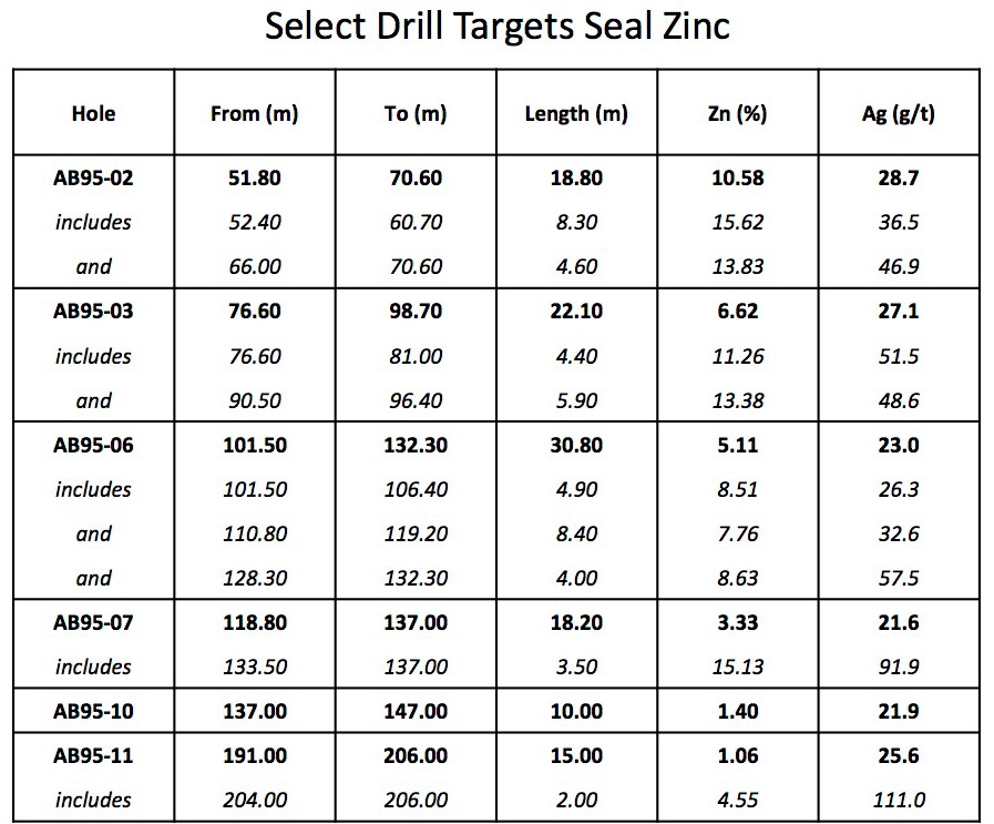
The prospect was evaluated with drilling by Cominco Ltd. between 1995 and 2001. During this time a total of 5,115 m of core was drilled in 32 holes. These efforts defined a zone of strata-bound zinc and silver mineralization that remains open. Highlights from the drilling are presented in the table below:
- 18.8 m core length grading 10.58% zinc (Zn) and 28.7 g/t silver (Ag) starting from 51 m depth.
- 30.8 m core length grading 5.11% Zn and 23.0 g/t Ag starting from 101 m depth.

Geology
The Storm Copper prospect and Seal Zinc deposit occur with the northern survey block, characterized by a mainly east-west structural-stratigraphic grain. The Seal Zinc deposit occurs on tidewater west of the Storm prospect, and comprises disseminated to massive sphalerite-pyrite-marcasite mineralization primarily in arenaceous sandstone at the base of dolostones of the Ship Point Formation. Previous drilling by Teck outlined a small but high-grade historic zinc-silver resource that was constructed prior to the implementation of NI 43-101 standards and that should not be relied upon. The historic resource was the subject of an independent NI 43-101 resource estimation (see the Seal Zinc section below). Newly acquired gravity data over both the Seal Zinc deposit area and the rocks along stratigraphic trend to the NW and SE delineate a strong gravity response coincident with the mineralization and the trend. The anomalous areas to the NW and SE have not previously been tested by diamond drilling. The Polaris zinc-lead deposit was discovered by drilling a blind gravity target in the vicinity of small surface showings, and the Company is encouraged by the potential for blind mineralization associated with these targets.
The southern, relatively poorly known, part of the Nunavut Property is underlain by north-south trending Paleozoic carbonate and Precambrian basement strata, with several base metal showings and areas of geological complexity of interest to Aston Bay. The central part of this area was covered by the new survey, which outlined a strong north-south pattern of alternating gravity highs and lows, possibly indicative of favourable horst-and-graben structures. Further refinement of the geology and survey results will be completed to guide ongoing exploration.
Recent Exploration
Aston Bay’s 2018 Drill Program
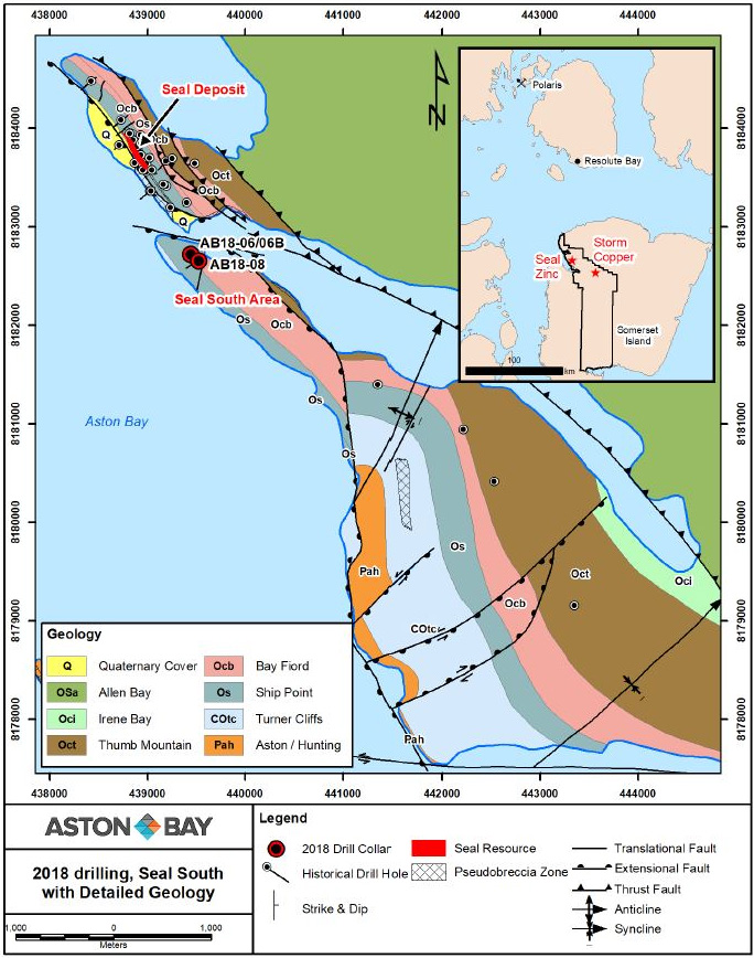
Aston Bay’s 2018 drill program consisted of 3,135 metres of drilling over a total of nine drill holes targeting high-grade copper mineralization in the vicinity of Storm Copper and adjacent prospects, as well as targeting Polaris-type zinc mineralization at the Seal Zinc deposit and the Seal South prospect. The program comprised seven holes at the Storm copper prospect and two along strike from the Seal zinc deposit. Targets were based primarily on interpreted gravity gradiometry anomalies proximal to known mineralisation at Storm and Seal. Unusually challenging weather reduced the planned meterage for this drill season and several anomalies remain untested. The majority of the drill holes were relatively shallow at approximately 300m or less.
Gravity target yields new zinc mineralized zone south of Seal
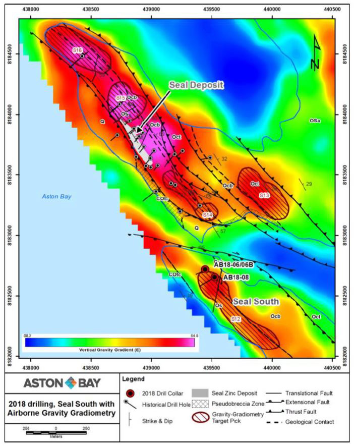
At Seal, only two holes were completed due to challenging weather conditions and an initial focus on Storm targets (Figures 7 and 8). Nonetheless, drilling was successful in discovering an interpreted extension of the Seal mineralised system approximately 1.2 km southwards along strike, in the northernmost part of the Seal South area and adjacent to tidewater. Drill hole AB18-06B targeted the extreme northern end of an 800m long positive gravity gradiometry anomaly (S12 on Figure 8) coincident with local subcropping sphalerite-pyrite mineralisation. After passing through locally weakly mineralised sandstone and dolomite of the lower Ship Point Formation, host to the Seal deposit, the drill hole intersected significant sphalerite mineralisation between 109.5 m and 136.0 m within moderately to strongly altered pseudobreccia, pyrite/marcasite and rubbly dolostone and limestone of the Turner Cliffs Formation. Results include:
- from 125.0 to 131.0m, 6.0m grading 0.67% Zn,
- including from 127 to 129m, 2.0m grading 1.11% Zn.
As at Seal, the mineralised pseudobreccia in AB180-06B is considered analogous to pseudobreccia present at the Polaris deposit, where it occurs as a lateral hydrothermal alteration equivalent to ore. The discovery of mineralised pseudobreccia at Seal South in the Turner Cliffs Formation is interpreted as a favourable indicator of hydrothermal alteration and the potential for additional stratiform zinc mineralisation in vicinity of Seal.
The last hole of the 2018 Seal program, AB18-08, was collared 100 m southeast along strike from AB18-06B. It intersected, at a similar position in the Turner Cliffs Formation, a 1m zone of sphalerite mineralisation from 132.0 to 133.0m grading 0.16% Zn, within a broader zone of weak mineralisation. Core recoveries in the zone were poor, only 38% in the specified interval.
The remaining ~700m strike length of the S12 gravity anomaly is untested and is a promising drill target for 2019. Four additional priority anomalies, S13 – S16, occur in close proximity to the Seal deposit (Figure 8) and also are untested, as are several other anomalies at Seal North (see August 1, 2018 press release).
NI 43-101 Mineral Resource Estimate
2018 Technical Report on Seal Zinc Deposit
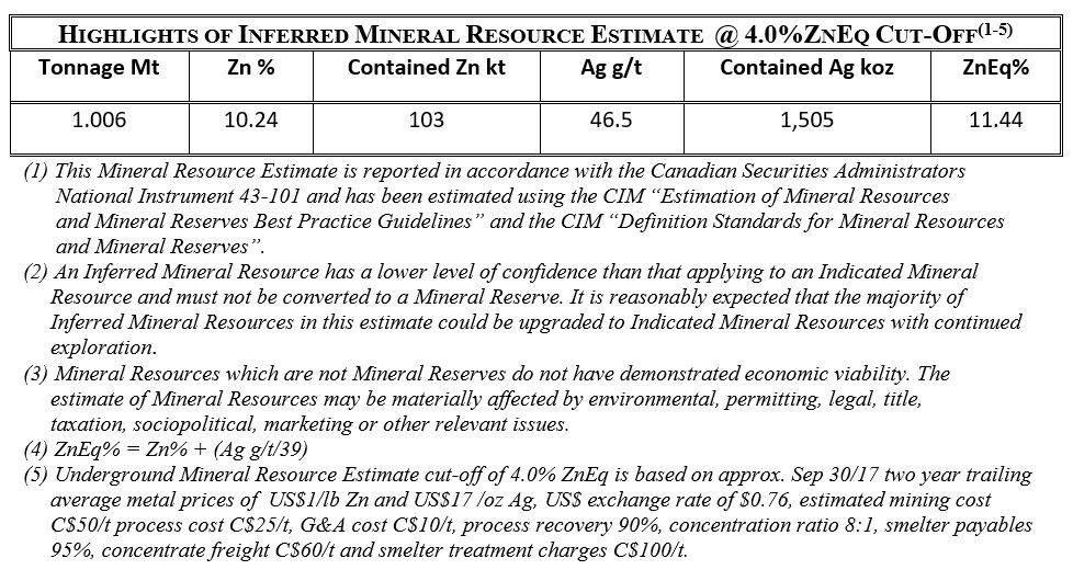
During the 2018 fiscal year, Aston Bay completed an initial mineral resource on its 100% owned Seal Zinc deposit. The deposit is a stratabound body hosted in sandy dolostone and sandstone within a thick section of Paleozoic dolostones, and was discovered by Teck in the mid-1990s. The Seal Zinc deposit is approximately 30 km to the west of the high-grade Storm Copper prospect.
The Seal Zinc deposit is estimated to contain 1.006 million tonnes (“Mt”) at a grade of 10.24% zinc and 46.5 grams per tonne (“g/t”) silver, using a cutoff of 4.0% zinc equivalent. The estimate is based on diamond drilling conducted by Teck in 1995-96 and Noranda in 2001.
Known mineralization has a thickness of up to 20 m, extends for over 400 m along strike and 50 to 100 m down-dip, and is partially fault-bound. Seal Zinc is interpreted to be a Mississippi Valley–type (“MVT”) deposit, with geological similarities to the Polaris deposit located to the north in the same Paleozoic dolostone succession. A large hydrothermal “pseudobreccia” alteration zone in the footwall of the deposit contains minor zinc mineralization and probably represents the feeder zone. MVT deposits are known to occur in clusters, and Aston Bay believes there is exploration potential along strike for discovery of additional mineralization.
The report titled “Initial Mineral Resource Estimate and Technical Report for the Seal Zinc Deposit, Nunavut Property, Somerset Island, Nunavut” is effective as of October 6, 2017 and signed January 17, 2018 (the “Technical Report”). The Technical Report was authored by independent Qualified Persons at P&E Mining Consultants Inc., and is in accordance with National Instrument 43-101 – Standards of Disclosure for Mineral Projects. The Technical Report is available at the bottom of this webpage and at www.sedar.com under the Company’s profile.
Highlights of the Technical Report include:
- P&E considers that the zinc and silver mineralization of the Seal Zinc deposit is potentially amenable to underground extraction;
- Recent geochronology on the nearby Storm Copper mineralization produced an age of 378.1 ± 1.3 Ma (Stein, 2016), within the range of uncertainty for the age of zinc mineralization at the nearby past-producing (20.1 Mt @ 13.4% Zn) Polaris mine at 374 ± 9 Ma (Selby et al., 2005; Dewing et al., 2007), and hence linking the Cu and Zn-Ag mineralization to the same regional metalliferous fluid flow event; and
- The Nunavut Property hosts a geological environment that is very favourable for additional base metal discovery, and further regional exploration is warranted to identify new areas of mineralization.
Highlights of the recommendations include:
- Evaluate data from the 2017 property-wide Falcon Plus airborne gravity gradiometry survey conducted by CGG Multi-Physics to further inform target definition;
- Further investigate the numerous copper and zinc anomalies along the 144 km structural trend; and
- Identify and prioritize future drilling targets.