Projects
Storm Copper Project
The Storm Copper Project is located on Somerset Island, Nunavut, approximately 20 kilometres from tidewater at Aston Bay. Storm Copper is a strata-bound and structurally-hosted copper zone of mineralization, hosted in dolomitic sediments of the Allen Bay Formation. Hypogene copper mineralization is present at surface and identified to a depth of at least 100 metres in the form of chalcocite, bornite, covellite and chalcopyrite. Malachite and azurite are common oxide coatings. The geologic setting, mineralogy and zonation suggest affinities to sediment-hosted copper deposits.
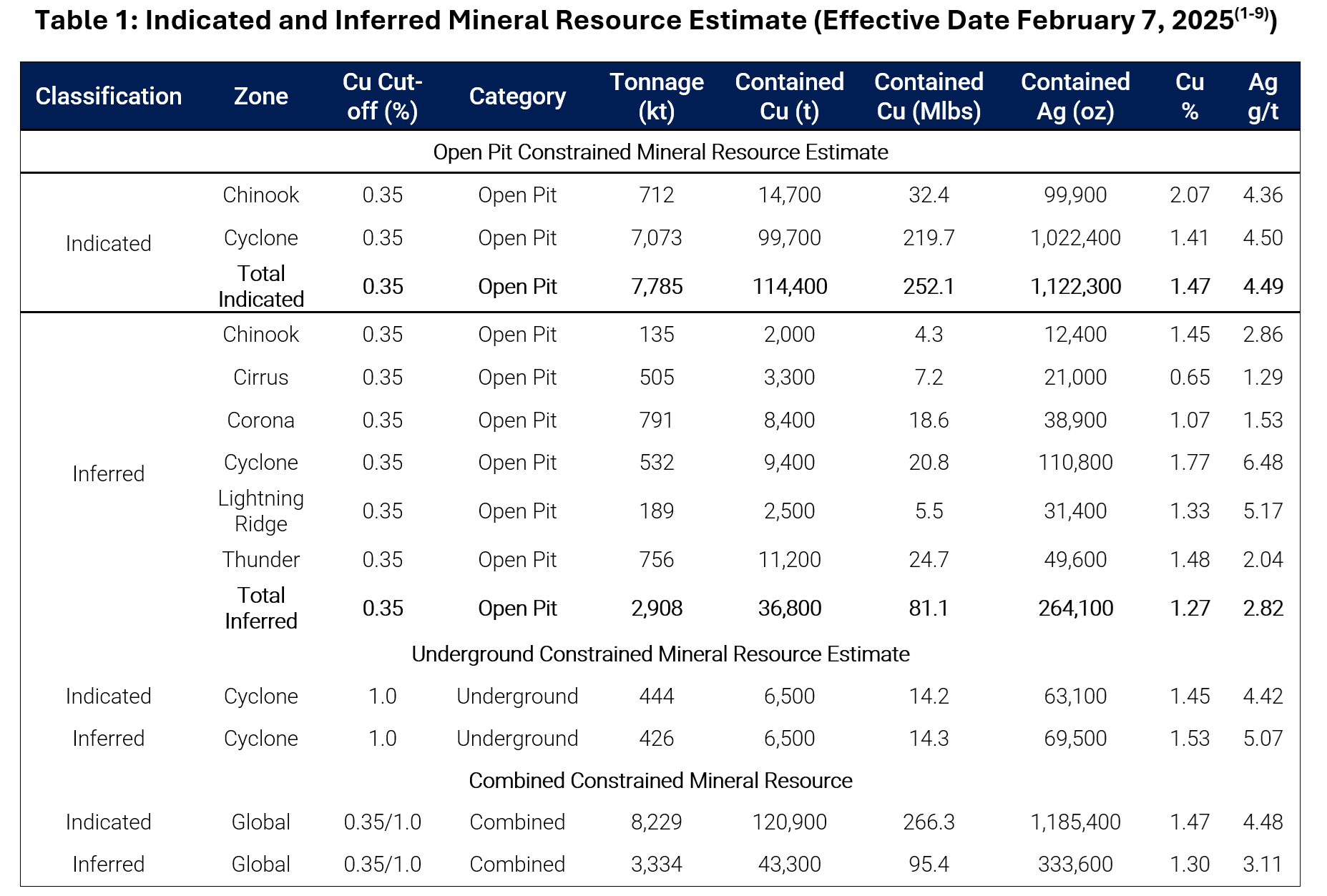
Initial Mineral Resource Estimate
As of February 7, 2025, the near-surface mineralization (<120 metres depth) at Storm includes:
Indicated Mineral Resources:
- 8.2 million tonnes at 1.47% copper (Cu) and 4.5 g/t silver (Ag)
- Containing 266.3 million pounds (121,000 tonnes) of copper
- Containing 1.185 million ounces of silver
Inferred Mineral Resources:
- 3.3 million tonnes at 1.30% Cu and 3.1 g/t Ag
- Containing 95.4 million pounds (43,000 tonnes) of copper
- Containing 333,600 ounces of silver
Key Features
- Near-surface mineralization: Less than 120 metres depth
- Open-pit potential: Over 90% of contained metal accessible by open-pit mining
- High-quality mineralization: 100% fresh, chalcocite-dominant copper sulphide
- Excellent metallurgy: Testwork confirms strong beneficiation potential, including sorting
Growth Opportunities
- All six deposits (Cyclone, Chinook, Corona, Cirrus, Lightning Ridge, and Thunder) remain open for expansion
- Cyclone Deeps discovery (2024) with 1.2% Cu over 10 m from 311 m depth
- New high-grade copper discoveries: The Gap, Squall, and Hailstorm
- Extensive exploration potential along 110 km copper belt and at depth
Seal Zinc-Silver Deposit
- The project also includes the Seal Zinc Deposit, located 28 km northwest of the Storm Copper deposits
- Seal Zinc Deposit Inferred Mineral Resources: 1.006 million tonnes at 10.24% zinc (Zn) and 46.5 g/t Ag
Note: Mineral Resources that are not Mineral Reserves do not have demonstrated economic viability.
Historical Exploration
Storm Copper has been explored intermittently since the 1960s; however, most of the historic work on the property was undertaken by Cominco Ltd. (now Teck Resources Ltd).
Sixty-seven holes (9,032.5 metres) were drilled at Storm between 1996 and 2000. These efforts defined four separate zones of copper mineralization — 2200N, 2750N, 3500N, and 4100N Zones — all of which remain open both laterally and vertically.
Highlights from the historic drilling at Storm Copper include:
- 110 metres (m) core length grading 2.45% copper (Cu) from surface at the 2750N Zone
- 56m core length grading 3.07% Cu from 12.2m depth at the 2750N Zone
- 49m core length grading 1.79% Cu starting at surface at the 2200N Zone
In addition to the historical drill results, a 3,970 line-kilometre Versatile Time Domain Electromagnetic (VTEM) airborne survey was completed over the property in 2011. The spatial correlation of conductance anomalies with mineralized intercepts in the historic drilling suggests that the near-surface copper mineralized zones of the Storm copper property can be accurately mapped and modeled with electromagnetic techniques. Three of the twelve holes drilled by BHP Billiton in 2016 targeted VTEM anomalies; all three intersected copper mineralization, including:
- 16m core length grading 3.07% Cu, starting at 93 m from surface at 4100N Zone (STOR1601D)
Aston Bay believes the Storm Copper project holds significant potential for further development, and is also indicates the potential for other mineralized zones concealed in the subsurface elsewhere on the property.
Geology
The Storm Copper prospect and Seal Zinc deposit occur with the northern survey block, characterized by a mainly east-west structural-stratigraphic grain. The Storm prospect comprises four high-grade, dominantly chalcocite occurrences associated with an east-west graben, partially delineated by prior diamond drilling (Figure 2). Copper-silver mineralization occurs both in close association with steeply dipping graben-bounding faults and as broadly stratiform mineralization lateral to the faults. The gravity survey returned strong responses along and within the graben, including three anomalies spatially associated with the 4100N, 2750N and 2200N occurrences; these anomalies extend well beyond the current drilling and are potential drill targets.
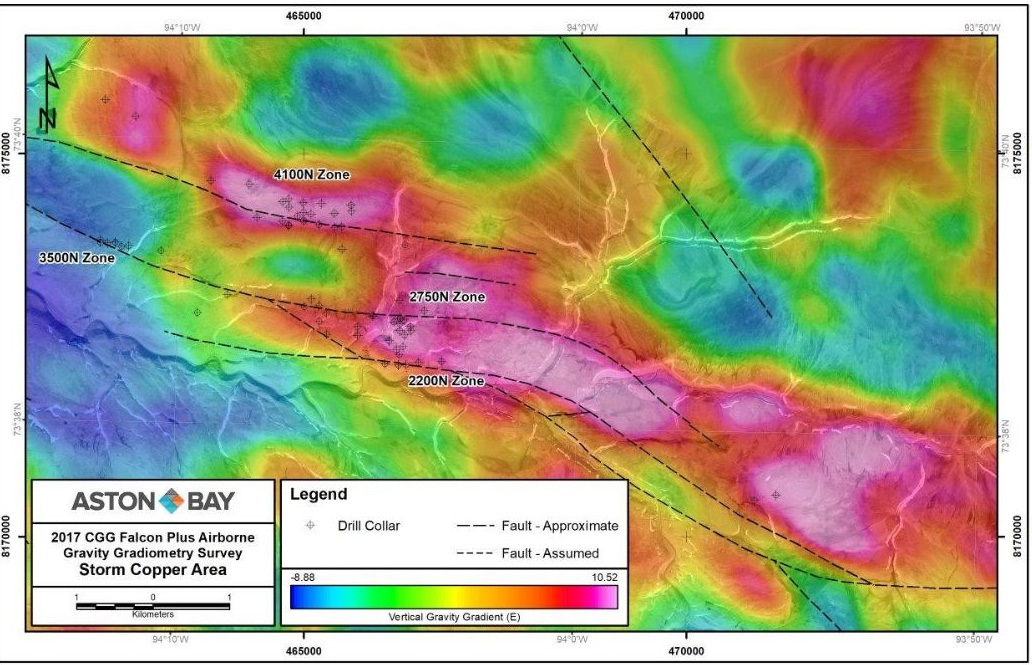
A fourth composite gravity anomaly occurs along the eastern extension of the Storm graben and is spatially associated with the Tornado copper occurrence, which to date has seen only two diamond drill holes. The gravity data suggest the presence of a second-order graben on the northern flank of the main structure, to date untested. A fifth gravity anomaly occurs along the northern flank of the Storm graben, west along strike from the large 4100N occurrence, and is also poorly tested to date.
The southern, relatively poorly known, part of the Nunavut Property is underlain by north-south trending Paleozoic carbonate and Precambrian basement strata, with several base metal showings and areas of geological complexity of interest to Aston Bay. The central part of this area was covered by the new survey, which outlined a strong north-south pattern of alternating gravity highs and lows, possibly indicative of favourable horst-and-graben structures. Further refinement of the geology and survey results will be completed to guide ongoing exploration.
Recent Exploration
Aston Bay’s 2018 Drill Program
Aston Bay’s 2018 drill program consisted of 3,135 metres of drilling over a total of nine drill holes targeting high-grade copper mineralization in the vicinity of Storm Copper and adjacent prospects, as well as targeting Polaris-type zinc mineralization at the Seal Zinc deposit and the Seal South prospect. The program comprised seven holes at the Storm copper prospect and two along strike from the Seal zinc deposit. Targets were based primarily on interpreted gravity gradiometry anomalies proximal to known mineralisation at Storm and Seal. Unusually challenging weather reduced the planned meterage for this drill season and several anomalies remain untested. The majority of the drill holes were relatively shallow at approximately 300m or less.
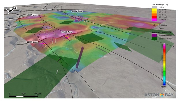
2021 Ground Electromagnetic (EM) Geophysical Surveys
Highlights
- Numerous shallow conductors identified coincident with drill confirmed high-grade copper mineralization
- Seven new untested shallow conductors of interest identified
- Seven new broad, untested deeper conductors of interest also identified
- The survey confirms the growth potential of the Storm high-grade copper system
The 2021 EM surveys, commissioned by Aston Bay’s partner American West Metals Limited (“American West”), targeted extensions along strike and at depth of known mineralization, and followed up on previous geophysical anomalies. The surveys were completed in August 2021 to enhance existing targets and identify new potential drill targets ahead of the proposed 2022 drilling campaign. Previous EM surveys have successfully identified several strong conductive anomalies that are associated with known copper mineralization in the Storm Project area, including a large conductive anomaly associated with the high-grade 4100N Zone (intercepts include 67.6 m @ 1.33% Cu from 43.4 m in hole ST99-47).
The 2021 EM surveys confirmed the correlation between elevated conductivity and high-grade copper mineralization at the main Storm Copper showings, producing numerous shallow conductors coincident with drill confirmed mineralization. Known high-grade copper mineralization at Storm is hosted in gently dipping Paleozoic carbonate rocks, along and adjacent to the northern and southern margins of a west-northwest to east-northeast trending, ~1 km wide, fault-bounded valley or graben. Inversion and plate modelling of the EM data also defined multiple prospective conductors associated with the Storm graben within areas previously untested by drilling.
Seven untested shallow conductors of interest were identified (Figures 1 and 2; dark blue rectangles): two east along strike from the 2200N and 2750N zones, two west-northwest along strike from the 4100N Zone, one immediately west of the drilled area of the 4100N Zone conductive anomaly, one northeast of the 4100N Zone, and one northeast of the 3500N Zone. All seven untested shallow conductors are located along or in close proximity to the bounding faults of the Storm graben, in areas of elevated density identified by the 2017 airborne gravity gradiometry (AGG) survey (see Aston Bay News Releases dated November 30, 2017 and June 21, 2018). The conductors east of the 2200N and 2750N zone are also associated with significant copper in soil geochemical anomalies.
Seven untested deeper conductors of interest were also identified in the Storm Copper area (Figures 1 and 2; dark green rectangles). These broad, low-amplitude anomalies are generally at least partially associated with areas of elevated density identified by the 2017 AGG survey. Six of the seven anomalies are located along or adjacent to the bounding faults of the Storm graben. The geometry and mostly gentle dips of the modelled deep conductors suggest that they may be related to stratiform type targets, and may be indicative of traditional sedimentary type copper mineralization at depth. Given the highly resistive nature of the host dolomites, even subtle conductors are considered to be prospective when combined with coincident geochemical or airborne gravity anomalies.